

Artscape will be held Friday, August 2nd through Sunday, August 4th. Traffic modifications for the event begin as early as Monday, July 29th. Mt. Royal Avenue and intersecting corridors will be CLOSED TO TRAFFIC during the event with additional parking restrictions in effect.
BALTIMORE, MD (July 26, 2024) - The Baltimore City Department of Transportation would like to advise motorists of the road closures and parking restrictions that will be in effect for Artscape which will take place from Friday, August 2nd through Sunday, August 4, 2024, in Mount Vernon, Bolton Hill, and Charles North and Station North Arts District. Motorists are encouraged to download the Waze.com app for live detour navigation.
In preparation for Artscape, roadway closures and operational changes will be implemented in phases beginning on Monday, July 29th at 7:00 a.m. Once the road closures are implemented, motorists will be rerouted to alternate routes as directed by the Baltimore City Police (BPD), Transportation Enforcement Officers (TEOs), signs and electronic message boards. Motorists should adhere to their directions for everyone’s safety. Residents, students, and visitors are encouraged to plan ahead for the road closures by using alternate routes and allowing additional travel time leading up to and during this event.
Motorists are also urged to pay close attention to posted parking restrictions throughout the duration of the event. Most parking restrictions start at 12:00 a.m. on Monday morning, July 29th, and vehicles parked in violation will be ticketed and relocated. Motorists with questions concerning the location of their vehicles should call 311.
After the event ends, some road closures will remain in place until 4:00 p.m. on Tuesday, August 6th. Roads will be reopened as soon as possible after all event-related materials and equipment are safely cleared from the streets.
In preparation for Artscape, the following road closures will be implemented:
Road closures from Monday, July 29th at 7:00 a.m. to Tuesday, August 6, 2024, at 4:00 p.m.:
Road closures from Wednesday, July 31st at 10:00 a.m. to Monday, August 5, 2024, at 6:00 a.m.:
Road closures from Friday, August 2nd at 9:00 a.m. to Monday, August 5, 2024, at 6:00 a.m.:
Throughout the event, North Avenue will remain OPEN to through traffic.
Special Traffic Pattern along Maryland Avenue for Sunday morning church services:
On Sunday, August 4th from 9:00 a.m. until 12:00 p.m., Maryland Avenue will be converted to a two-way traffic pattern from Preston Street to Mt. Royal Avenue for morning church services. Congregation members trying to access the church should follow St. Paul Street to Preston Street, then turn right going the opposite way onto Maryland Avenue to the parking lot.
Charm City Circulator Service:
Charm City Circulator (CCC) patrons should be aware that CCC bus operations along the Purple Route will be modified starting next week in preparation for Artscape. On Monday, July 29, 2024, Purple Route modifications will be in effect through Tuesday, August 6, 2024, with normal operations resuming on Wednesday, August 7, 2024. Patrons riding the CCC may experience delays and longer than normal wait times. Additional information can be found on the CCC website.
Information about the 2024 Artscape event can be found at https://www.artscape.org/.
###
Department of Transportation to Resume Daily Storage Fees for Impounded Vehicles Starting Monday, July 22nd
BALTIMORE, MD (July 18, 2024) – The Baltimore City Department of Transportation (BCDOT) announced today that it will soon resume the assessment of daily storage fees for vehicles impounded at its Pulaski Highway and Fallsway Facilities.
Starting on Monday, July 22, 2024, daily storage fees for impounded vehicles will resume. The resumption of these towing fees coincides with the resumption of late fees on outstanding parking penalties, which was announced in June 2024. These fees were also paused throughout much of the COVID-19 pandemic and their resumption is critical for FY2025, as outlined in this year’s budget process.
Vehicles at the Pulaski Highway or Fallsway facilities that remain impounded after the initial 48 hours will be charged a storage fee of $15 per day for 2-axel vehicles with 4 wheels, including weekends and holidays. Larger vehicles such as dually trucks with six wheels or those with 3 or more axels will be charged a storage fee of $30 per day.
Owners of vehicles that are currently impounded are encouraged to retrieve their vehicles before July 22, 2024, to avoid having daily storage fees assessed. Before vehicles are released, the proper documentation must be provided, including proof of ownership, and verified by BCDOT staff. In addition, all towing and storage fees along with any citations associated with the vehicle must be paid. Please note that towing and storage fees are waived for stolen vehicles with proper documentation.
Motorists are encouraged to call 410-396-9958 to schedule an appointment at the Pulaski Highway facility or visit Towing.BaltimoreCity.gov/Vehicle-Recovery for additional information.
###

Mayor Scott, BCDOT Announce Start Date for Expanded Charm City Circulator Service in Cherry Hill Community
New Circulator Route Will Begin Running on June 23, 2024

BALTIMORE, MD (Wednesday, May 22, 2024) – Today, Mayor Brandon M. Scott and Department of Transportation Director Corren Johnson announced expanded service improvements to the Charm City Circulator (CCC), the City of Baltimore’s fare-free bus service providing transit in the downtown area and beyond, will be implemented on June 23, 2024. The service enhancements include a long-anticipated new CCC route, which will serve the Cherry Hill neighborhood, as well as changes to the northern and southern ends of the Purple Route.
The new northern end of the Purple Route extension will connect residents to a hospital system and food hub. The addition of the Cherry Hill Route is a service connection lauded by community and transit advocates as an important step in service equity for Baltimore City. Many residents and businesses alike see the route as an opportunity for enhanced connectivity, greater economic mobility, and a more reliable commute. The expanded network will allow ease of access to job opportunities, entertainment, and all Downtown Baltimore has to offer.
The new Cherry Route will operate between the Inner Harbor and Cherry Hill in southwest Baltimore. Destinations along this new route include Federal Hill, Riverside, McHenry Row, Baltimore Peninsula, Middle Branch Park, MedStar Harbor Hospital, and the Cherry Hill Light Rail Station. Circulator buses along this route will run on a 20-minute frequency.
In addition to the new Cherry Route, the alignment along the Purple Route will be modified. Because the Cherry Route will serve the Federal Hill neighborhood, the Purple Route will no longer travel south of Montgomery Street. Additionally, on the north end of the Purple Route, service will be extended east along 33rd Street to Greenmount Avenue. Additional destinations served along the Purple Route’s new extension include MedStar Union Memorial Hospital and Giant Food.
The Cherry Route will operate on a 20-minute frequency; the Purple Route will operate on a 13-minute frequency; the Orange Route will operate on a 10-minute frequency; the Green Route will operate on a 20-minute frequency; and the Banner Route will operate on a 40-minute frequency.
These service improvements were derived through the Transit Development Plan (TDP) process, which took place throughout 2021 and 2022. The TDP aims to create a roadmap for the Circulator’s future and improve the equity of service. These changes utilize the Circulator’s existing 23-bus fleet and are within the CCC’s existing budget.
The Baltimore City Department of Transportation continues to coordinate with partner agencies and other stakeholders to determine implementation timelines and feasibility of additional changes laid out in the Transit Development Plan.
A service map reflecting the changes that take effect on June 23 is shown below.
###

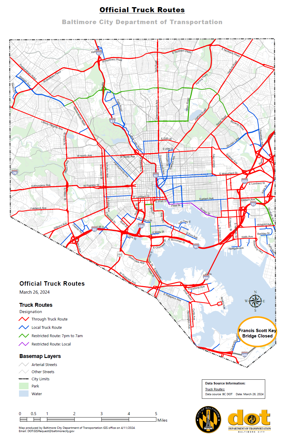
Tuesday, March 26, 2024 - The Baltimore City Department of Transportation has been working closely with local, state, and federal partners since the collapse of the Francis Scott Key Bridge early this morning.
The Baltimore City Department of Transportation is actively evaluating the projected impact of the bridge collapse on City corridors, particularly our designated truck routes. Higher traffic volumes on City roads are anticipated, particularly along designated truck route corridors, and the Baltimore City Department of Transportation is actively working on plans to help mitigate the impact on local communities.
In order to minimize impacts, the Baltimore City Department of Transportation is modifying our official truck map which details how truck drivers may use Baltimore City roads and highways. Please refer to the GIS map for the most up-to-date route information: Baltimore City Official Truck Routes (arcgis.com).
Truckers are encouraged to continue checking this official map in the coming days as additional modifications may be made.
Motorists should also be aware that portions of Fort Armistead Road and Hawkins Point Road are closed at this time. Drivers are encouraged to download the Waze.com app for live detour navigation.

Tuesday, March 26, 2024 - Mayor Brandon M. Scott has officially declared a local State of Emergency in response to the Francis Scott Key Bridge collapse. The Executive Order mobilizes the City of Baltimore’s Emergency Operations Plan to deploy emergency resources to protect the persons affected by the incident and expands the resources available to tackle the emergency situation.
